Valley Bottom
Summary
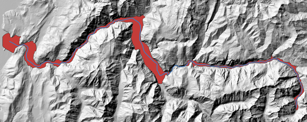
Extract valley bottom from a DEM and a stream network.
Tags:hydrography, spatial components, valley bottom, detrend, relative, dem, alluvial floodplain, stream network
Usage
Within a watershed, extraction of a valley bottom related to a hydrographic network is a crucial step for the fluvial corridor characterization. Defined as the modern alluvial floodplain (Alber & Piégay, 2011)1, valley bottom is the deposition zone of alluvium since Holocene (Gregory, 1979)2 and includes both riverbed and floodplain. This valley bottom crucial fluvial unit with important water, material and biota transfers (Nanson & Croke, 1992)3. Valley corridor width also controls fluvial dynamics and patterns so that extracting this layer is often a preliminary step in the biogeomorphic characterization of stream networks (Notebaert & Piégay, 2013; Roux et al., 2014)45.
3 methods to detrend DEM are proposed:
- Topological is identical to (Roux et al., 2014)5 and (Alber & Piégay, 2011)1.
- Nearest is fast and helpful if your stream network does not match perfectly with your DEM.
- Flow is slower, but precise. You may need to fill depressions of your DEM and resolve flat lands before trying to extract the valley bottom.
Parameters
| Parameter | Description | Type |
|---|---|---|
Input DEM
IN_DEM
|
Input raw DEM coded on Float32
Default value: [3]
|
RasterLayer |
Input stream network
IN_STREAM
|
Input stream network | LineString |
Detrending method
METHOD
|
Detrending method (see documentation above)
Default value: Topological
|
Enum |
Disaggregation step (topological detrending only)
STEP
|
Distance of stream network segmentation
Default value: 50.0
|
Number |
Isolated objects aggregation distance
AGGREG
|
Maximal distance to aggregate small parts of valley bottom extracted
Default value: 5.0
|
Number |
Max width (large buffer size)
BUFFER
|
Size around the stream network in which the valley bottom will be researched
Default value: 1500.0
|
Number |
Minimum relative height value
THRESH_MIN
|
Minimum elevation to extract from the Relative DEM
Default value: -10.0
|
Number |
Maximum relative height value
THRESH_MAX
|
Maximum elevation to extract from the Relative DEM
Default value: 10.0
|
Number |
Simplify Valley Bottom tolerance
SIMPLIFY
|
Simplification tolerance of the valley bottom polygon (in projection unit)
Default value: 10
|
Number |
Smooth Valley Bottom iterations
SMOOTH
|
Smoothing iterations of the valley bottom polygon
Default value: 5
|
Number |
Output valley bottom
OUT_VB
|
Output valley bottom polygon | Polygon |
See Also
-
Alber, A., & Piégay, H. (2011). Spatial Disaggregation and Aggregation Procedures for Characterizing Fluvial Features at the Network-Scale: Application to the Rhône Basin (France). Geomorphology, 125(3), 343–360. https://doi.org/10.1016/j.geomorph.2010.09.009 ↩↩
-
Gregory, K. J. (1979). The fluvial system, S. A. Schumm, New York, Wiley, 1977. No. of Pages: 338. price: £16.50. Earth Surface Processes, 4(1), 97–98. https://doi.org/10.1002/esp.3290040121 ↩
-
Nanson, G., & Croke, J. C. (1992). A genetic classification of floodplains. https://ro.uow.edu.au/articles/journal\contribution/A\genetic\classification\of\floodplains/27708159 ↩
-
Notebaert, B., & Piégay, H. (2013). Multi-scale factors controlling the pattern of floodplain width at a network scale: The case of the Rhône basin, France. Geomorphology, 200, 155–171. https://doi.org/10.1016/j.geomorph.2013.03.014 ↩
-
Roux, C., Alber, A., Bertrand, M., Vaudor, L., & Piégay, H. (2014). “FluvialCorridor”: A new ArcGIS toolbox package for multiscale riverscape exploration. Geomorphology. https://doi.org/10.1016/j.geomorph.2014.04.018 ↩↩